


All Products
-
Digital Inclinometer Sensor
-
Analog Inclinometer Sensor
-
Dynamic Inclinometer
-
Wireless Inclinometer
-
Electronic Compass Sensor
-
Attitude And Heading Reference System
-
IMU Inertial Measurement Unit
-
Accelerometer Vibration Sensor
-
GNSS INS Integration
-
Tilt Switch Sensor
-
Fiber Optical Gyroscope
-
Gyroscope Sensor Chip
-
Accelerometer Chip
-
Others
Contact Person :
Zhang
Phone Number :
86 18921292620
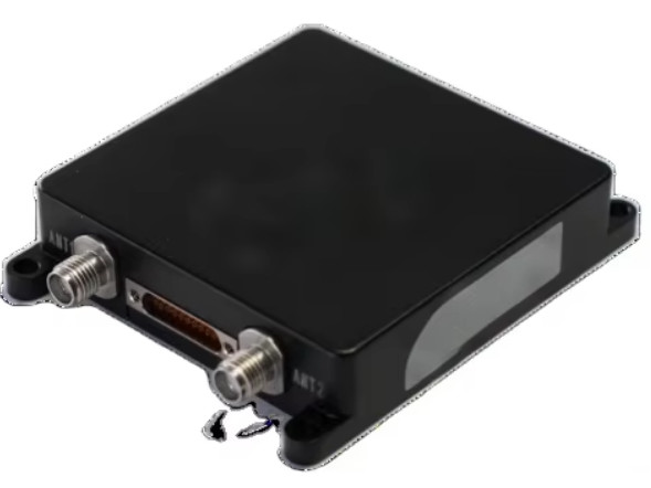
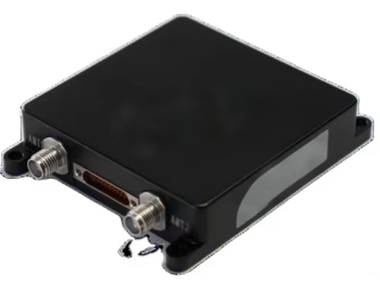
BW-6222-High-Precision-MEMS-Intergrated Navigation System
| Place of Origin | Jiangsu,China |
|---|---|
| Brand Name | BWSENSING |
| Model Number | BW6222 |
| Minimum Order Quantity | 1 PCS |
| Price | USD 5000-1000 |
| Payment Terms | T/T |
Product Details
| Axis | 3 Axis Inertial System | GyroscopeDynamic Range | ±250°/s |
|---|---|---|---|
| Gyroscope Bias Stability | 3°/h (10-second Average) | Accelerometer Dynamic Range | ±8 G |
| Operating Temperature | -40°C~+85°C | Accelerometer Bias Stability | 0.02 Mg (10-second Average) |
| Interfaces | RS-232, CAN/CAN-FD, PPS, And EVENT |
You can tick the products you need and communicate with us in the message board.
| Bias stability |
|---|
Product Description
Overview
The BW-6222 is a compact, high-precision MEMS modular navigation system.. It integrates a self-developed high-precision MEMS IMU(Inertial Measurement Unit) and a dual-antenna GNSS module, utilizing multi-source Kalman filter fusion algorithms to deliver continuous, reliable high-accuracy positioning and navigation data in complex environments. Applications include satellite communications, drones, surveying and mapping, and stabilization platforms.
Key Features
Multi-Constellation Support: Compatible with BDS, GPS, GLONASS, Galileo, and QZSS systems, including BeiDou-3 satellites
Factory-Calibrated IMU:
Temperature and dynamic calibration for all IMU components.
Adaptive Alignment:
Static/dynamic alignment optimization for motion or stationary states.
Error Compensation:
System-level calibration for installation misalignment and wheel speed ratio errors.
Positioning Accuracy:
Horizontal position error ≤0.2% × D (distance traveled) during GNSS signal loss
.
Interfaces:
RS-232/422, CAN/CAN-FD, PPS, and EVENT protocols for flexible integration.
Power Supply:
9–36 V DC wide-range input for industrial compatibility.
Functional Specifications
Core Functions
The system combines high-precision GNSS modules (centimeter-level positioning) with factory-calibrated MEMS IMU data (optionally augmented with odometer and steering inputs). Advanced algorithms (multi-source Kalman filtering, data source validation, and error compensation) ensure sustained accuracy in challenging environments (e.g., urban canyons, tunnels).
Key Performance Metrics
Data Update Rates
- GNSS Solution 20 Hz -
- Navigation Solution 200 Hz -
- Raw GNSS Data 10 Hz -
- Raw IMU Data 200 Hz -
Technical Advantages
Miniaturized Design: Compact dimensions optimized for UAVs, robotics, and portable systems
.
Dual GNSS Antenna Support: Enhanced positioning reliability with real-time kinematic (RTK) corrections.
Military-Grade Robustness: Operates in -40°C to +85°C and withstands shock/vibration (tested per GJB standards)
.
Applications
Satellite Communications: Stabilized platforms for ground terminals.
Autonomous Vehicles: Sub-meter positioning in GNSS-denied zones.
Surveying & Mapping: High-precision trajectory tracking.
Industrial Machinery: Motion control for heavy equipment.
Recommended Products